In 2017, I was learning about treaty relationships and land acknowledgements. As a way to avoid falling into the the trap of letting a land acknowledgement become simply a repetition without substance, I challenged myself to learn the particular history of treaties near my home, in the Annapolis Valley of Nova Scotia, Canada. What follows is what I think I understand so far. If you have new information or additional sources, I would love to learn more. Please keep in mind that I am not a historian, and this is not an academic paper. Just a record of where I am in my learning so far.
Annapolis Valley: A Birthplace of Treaties

| Figure 1 Mi’kma’ki (24) |
The land now called “Annapolis Valley” runs through the Mi’kmaw districts of Sipekne’katik (“land of abundant wild potatoes”) and Kespukwitk (“land ends”). The earliest known archaeological evidence of Mi’kmaw encampment is also in the Sipekne’katik district, near what is now Debert. The ancestors of today’s Mi’kmaq were living there around the same time that people first settled in what would eventually become Jericho – at least 10,500 years ago. (1)
From winter camps inland, the Mi’kmaq traditionally moved to coastal fishing villages in the summer, where sea winds provided relief from the interior’s mosquitoes and blackflies. There, they trapped, gathered wild plants, hunted porpoises and whales in square-rigged ocean-going canoes, and fished for gaspereau, shad, salmon, eel, and more. They built complex stone weirs that would last for centuries. (2)
The Mi’kmaq were among the first Indigenous Peoples to encounter Portuguese, Basque, English, and French fishers. The French claimed in the 1600s that they, not the Mi’kmaq, held title to the land. This was based on Pope Alexander VI’s 1493 “Doctrine of Discovery” – a Papal Bull that stated that only subjects of Christian monarchs could hold land title (see the original Bull and a full translation). (3)
1610: Baptism of Grand Chief Membertou at Port-Royal
In 1605, French colonists established a settlement at Port-Royal. By 1606, King Henry IV had granted the local fiefdom to a member of the settlement party, Jean de Poutrincourt, who was also named governor of the colony – despite having made no treaty or purchase from the Mi’kmaq.
The settlers built a log stockade fortification called a “habitation”, and established relations with the Mi’kmaq – including leaving the fort in the care of the Mi’kmaq from 1607 to 1610. Grand Chief Membertou was baptised there by French priests in 1610.
For over 100 years, governors for the French and English fought for control of what they called Acadia. The colony of Acadia included present-day Nova Scotia, New Brunswick, Prince Edward Island, parts of Quebec, and Maine as far south as the Kennebec River – roughly the same boundaries as Mi’kmaw territory.
Sometimes several kings simultaneously claimed the land, though none had negotiated with Indigenous peoples for that right.
The military fort at Port-Royal was an important strategic base. However, for decades, very little civilian settlement occurred beyond it.
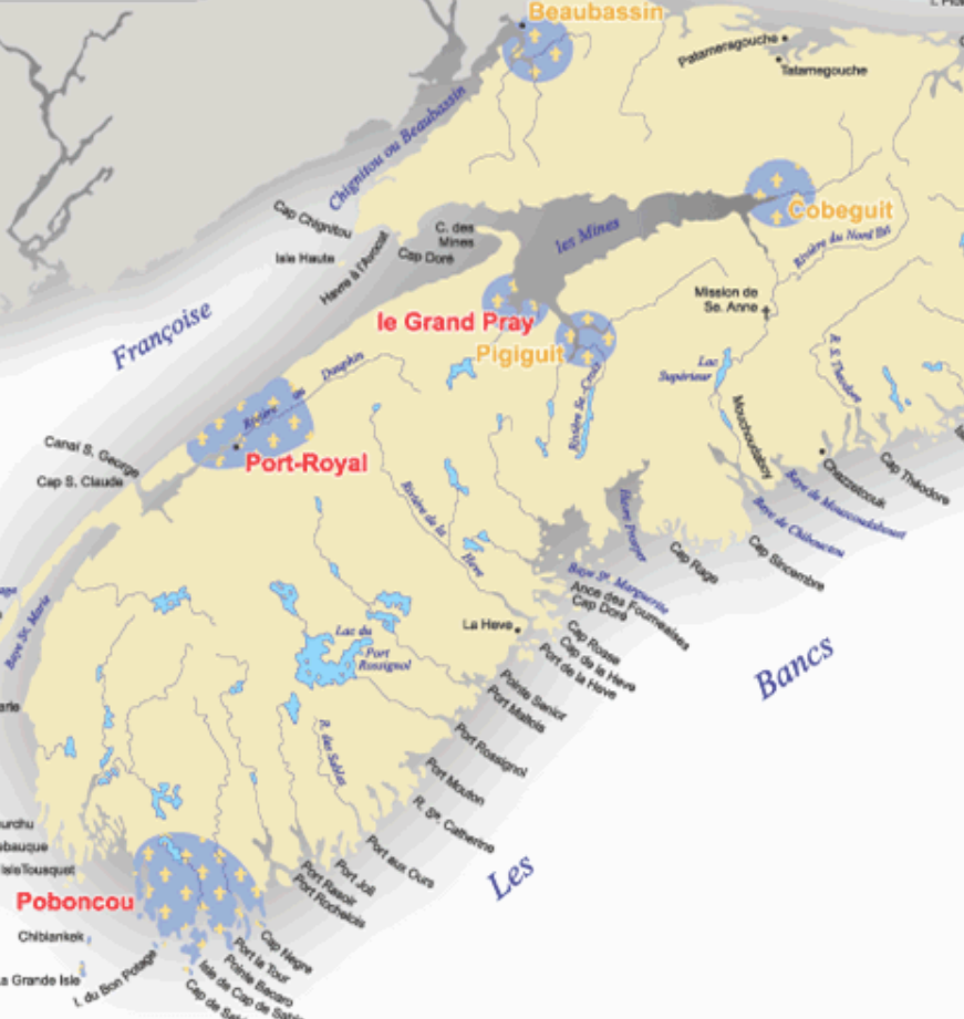
| Figure 2 Detail from Map of Acadia Before 1755 (26) |
By 1670, Acadian settlers were starting clusters of farms outside of Port-Royal, for example at Grand Pré and Pigiguit (also spelled Piziguid, near current Falmouth and Windsor).
1676 – 1721: Treachery and Treaties
In 1676, the Mi’kmaq, Wəlastəkwewiyik, Passamaquoddy, Penobscot, and Abenaki founded the Wabanaki Confederacy. That year, the Confederacy was invited to a peace conference with the English in New Hampshire under Major General Waldron. Instead of arriving at a conference, the 400 Wabanaki delegates were captured; eight were hanged; more were sold into slavery. Invitations to peace talks were to be intertwined with violence and treachery for 100 years.
English authorities declared bounties on the lives of the Confederacy peoples in 1689, 1703, 1722, 1744, 1749 (by Governor Edward Cornwallis) and 1756 (by Governor Charles Lawrence). The bounties were not restricted to combatants or even adults; rewards were paid for the killing of adults of all genders and children of all ages. This was also the period of most intensive treaty-making between the Confederacy and the English (soon to be British) Crown.

| Figure 3 Detail from French map of 1720 North America, by Henri Chatelain (25) |
The 1699 Treaty of Mare’s Point was an early treaty between the Massachusett’s Bay Colony and the Confederacy. The Confederacy considered that the English had agreed to keep their settlements west of the Kennebec River (current western Maine – see map below for Kennebec River and Fort, marked “R. et F. de Kinibecki”).
However, British forces in 1710 besieged and took control of Port-Royal, renaming it Annapolis Royal after Queen Anne. British civilian settlements began to expand northward in 1717.
In 1721, the Confederacy along with the Innu and Wendat sent a “letter of ultimatum” to the Governor-General of New England. They demanded that the English withdraw from what the Confederacy considered illegal settlements in eastern Maine. Conflict escalated and the Province of Massachusett’s Bay declared war on the Wabanaki Confederacy in 1722. Another scalping bounty was announced against them by New England, and 22 Mi’kmaq were taken hostage while visiting Annapolis Royal. The Wabanaki then took control of most of Maine, besieged the British at Annapolis Royal, and made advances on Massachusetts Bay strongholds. The colonial army retaliated by burning villages. (6)
1725: What Do the Treaties Say?
In 1725, the Indigenous groups dropped their requirement that the English abandon all settlements as far south as Boston, “in return for a comprehensive proposal on Land-Rights.” (6) Indigenous and British negotiators met in Boston. Major Paul Mascarene of Annapolis Royal also attended, bringing with him a proposed treaty text that stated,

| Figure 4 Original Treaty of 1725, held at the Nova Scotia Archives (7) |
“Articles of Submission… Whereas, His Majesty King George…is become the rightful possessor of the Province of Nova Scotia or Acadia … [we do] acknowledge His said Majesty King George’s jurisdiction and dominion over the territories of the said Province of Nova Scotia or Acadia, and make our submission to His said Majesty in as ample manner as we have formerly done to the King of France.” (7)
Chief Laurence (Loron) Saguouarram, one of the Penobscot delegates, described his objection in a 1727 speech that survives today:
“Thereupon, he said to me – Let us observe the treaties concluded by our Fathers, and renew the ancient friendship which existed between us. I made him no answer thereunto. Much less, I repeat, did I, become his subject, or give him my land, or acknowledge his King as my King. This I never did, and he never proposed it to me. I say, he never said to me – Give thyself and thy land to me, nor acknowledge my King for thy King, as thy ancestors formerly did.
“He again said to me – But do you not recognize the King of England as King over all his states? To which I answered – Yes, I recognize him King of all his lands; but I rejoined, do not hence infer that I acknowledge thy King as my King, and King of my lands. Here lies my distinction – my Indian distinction. God hath willed that I have no King, and that I be master of my lands in common. (8)
However, the section was never removed from the treaty. This is the first of what is commonly called the “Treaties of Peace and Friendship.” (9) The original manuscript (10), signed by all parties, is held at the Nova Scotia Archives; detailed photos and full text of this and many other treaties are available on their website.
The section most clearly indicating that the land title and traditional rights are not surrendered reads:
Saving unto the Penobscot, Naridgwalk and other Tribes … all their lands, liberties and properties not by them conveyed or sold to or possessed by any of the English subjects as aforesaid. As also the privilege of fishing, hunting, and fowling as formerly. (11)
1744-1759: Role of Scalping Proclamations in the Founding of Halifax
| The British alternated between war and peace repeatedly for the next several years: (12) (13) | |
| 1744 | Province of Massachusett’s Bay declares war on Mi’kmaq and Wəlastəkwewiyik (sometimes called “Maliseet”), issues bounty |
| 1749 | Halifax founded by Governor Cornwallis; Peace and Friendship Treaty reaffirmed |
| 1749 | Cornwallis issues bounty against Mi’kmaq after a Council meeting, which decided “That in their opinion, to declare war formally against the Micmac Indians would be a manner to own them a free and independent people… That, a Company of one hundred men be raised in New England to join with Gorham’s [Army Rangers] during the winter, and go over the whole province… [and therefore] do hereby authorize and command all Officers Civil and Military, and all His Majesty’s Subjects or others to … destroy the Savage commonly called Micmac, wherever they are found, and … do promise a reward of ten Guineas for every Indian Micmac taken or killed, to be paid upon producing such Savage taken or his scalp…” (14) |
| 1752 | Cornwallis rescinds bounty, then resigns |
| 1752 | Peace and Friendship Treaty reaffirmed, signed by Chief Jean-Baptiste Cope and representatives of the Crown (15). October 1 is the agreed-upon date for the British to present gifts in exchange for use of Mi’kmaq land, eventually giving rise to Treaty Day. |
| 1755 | Acadian civilians expelled, for fear that they may join with the Mi’kmaq and fight the British |
| 1756 | Governor Lawrence reinstates scalping bounty |
| 1759 | Colonial army near Digby attacked and slew most of a Mi’kmaq encampment while they slept |
1760 – 1789: Military Violence Declines, Economic Violence Takes the Fore
In 1760, the original Peace and Friendship Treaty is again reaffirmed in Halifax, followed in 1762 by Lieutenant Governor Jonathan Belcher’s proclamation “forbidding the settlement or trespass of certain lands claimed by natives.” (6) This marks the end of official warfare between the Mi’kmaq and the British Crown. Some suggest that this was the reason for modifying the traditional Mi’kmaw 7-pointed star, representing the 7 districts, into an 8-pointed star, to demonstrate peace with the British Crown, although 8-pointed star petroglyphs have been dated before 1500 (16) and there are other possible interpretations (17).
The British policy of genocide shifting emphasis from military (12) to economic, cultural, and educational means – eventually formalized, among other examples, in the Gradual Civilization Act of 1857 (18). The already-cleared and dyked farms of the dispossessed Acadians, in the famously fertile land of abundant wild potatoes that we now call the Annapolis Valley, were offered to British subjects in 1760; they became the Planters. Settlers were encouraged to clear and farm additional land on Mi’kmaq hunting grounds, which disrupted animal migration patterns and Mi’kmaq freedom of movement. “Without access to their different seasonal hunting and gathering territories, their traditional economy collapsed… within a single generation.” (19) Loyalist refugees from the American War of Independence were also encouraged to settle and take up farming on traditional Mi’kmaq territories; among these are the earliest Quakers in Nova Scotia. (20) Formerly-enslaved Africans, called the Black Loyalists, were promised land, but found when they arrived that many would be required to fortify the Citadel against the Mi’kmaq and Acadians, before they were given the least desirable plots. (21) Although some Mi’kmaq took up farming as well, the best farmland had been granted already.
In response to the sudden and widespread poverty that had arisen among the Mi’kmaq, colonial authorities ignored the underlying problems of access to land and instead focused on encouraging the Mi’kmaq to take up wage-labour by “improving” their education. In 1789, the first colonial schools for Mi’kmaw children would be established; these were the precursors of residential schools. (6)
 |
 |
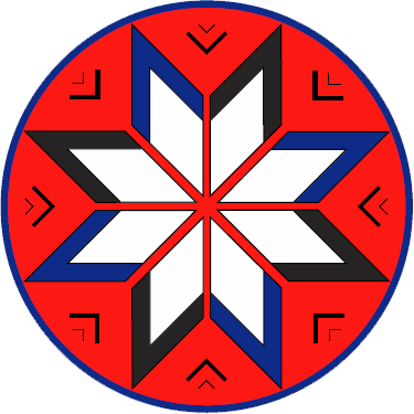 |
| Figure 5 Kejimkujik petroglyph representing the seven districts (22) | Figure 6 Eight-Pointed Star petroglyph from Bedford Barrens (16) | Figure 7 Eight-Pointed Star as used by the Tripartite Forum representing the Mi’kmaq, as well as the Canadian provincial and federal governments (23) |
Bibliography
- Muiniskw. MI’KMAW HISTORY. Mikmaw Spirit. [Online] March 25, 2016. [Cited: April 20, 2017.] http://www.muiniskw.org/pgHistory1.htm.
- Muin’iskw. MI’KMAW DAILY LIFE. Mikmaw Spirit. [Online] March 27, 2016. [Cited: April 20, 2017.] http://www.muiniskw.org/pgCulture1a.htm.
- The Gilder Lehrman Institute of American History. The Doctrine of Discovery: On This Day, 1493. The Gilder Lehrman Institute of American History. [Online] 2017. [Cited: May 15, 2017.] https://www.gilderlehrman.org/history-by-era/imperial-rivalries/resources/doctrine-discovery-1493.
- Muiniskw. MI’KMAW HISTORY – Post-Contact Timeline. Mikmaw Spirit. [Online] April 1, 2016. [Cited: April 20, 2017.] http://www.muiniskw.org/pgHistory2.htm.
- J. Willard, Secretary of the General Court or Assembly of the Province of Massachusetts Bay, and various leaders from First Nations in Nova Scotia and New Englan. Treaty of 1725 for Ratification at Annapolis Royal. Nova Scotia Archives. [Online] May 2017. [Cited: May 15, 2017.] http://novascotia.ca/archives/mikmaq/archives.asp?ID=615.
- Paul, Daniel. Journey of Hope: Gathering to Ratify the Treaty of 1725. We Were Not the Savages. [Online] [Cited: April 20, 2017.] http://www.danielnpaul.com/TreatyOf1725Ratified-1726.html.
- Mi’kmaq Rights Initiative. Treaties. Mi’kmaq Rights Initiative. [Online] [Cited: April 20, 2017.] http://mikmaqrights.com/negotiations/treaties/.
- General Assembly of the Province of Massachusetts Bay and various leaders from First Nations in Nova Scotia and New England. Treaty of 1725 for Ratification at Annapolis Royal. Nova Scotia Archives. [Online] 1725. [Cited: April 21, 2017.] https://novascotia.ca/archives/mikmaq/archives.asp?ID=615.
- Paul, Daniel. Treaty of 1725. We Were Not the Savages. [Online] [Cited: April 20, 2017.] http://www.danielnpaul.com/TreatyOf1725.html.
- —. British Scalping Proclamation – 1744. We Were Not the Savages. [Online] [Cited: April 20, 2017.] http://www.danielnpaul.com/BritishScalpProclamation -1744.html.
- —. Slaugher of Innocents. We Were Not the Savages. [Online] [Cited: April 20, 2017.] http://www.danielnpaul.com/BritishGenocide -1759.html.
- —. Scalp Proclamation 1949. We Were Not the Savages. [Online] [Cited: June 5, 2017.] http://www.danielnpaul.com/BritishScalpProclamation-1749.html.
- Sipekne’katik. HIstory. Sipekne’katik. [Online] 2016. [Cited: May 20, 2017.] http://sipeknekatik.ca/history/.
- Unknown. MP001. Nova Scotia Museum. [Online] [Cited: May 15, 2017.] https://novascotia.ca/museum/mikmaq/?section=image&page=&id=2&period=®ion=.
- Benoit First nation. Eight-Pointed Star and its Meaning. Benoit First Nation. [Online] 2016. [Cited: May 15, 2017.] http://www.benoitfirstnation.ca/pointed_star.html.
- Developments, Christian Aboriginal Infrastructure. Laws (Text). Christian Aboriginal Infrastructure Developments. [Online] September 15, 2015. [Cited: May 18, 2017.] http://caid.ca/GraCivAct1857.pdf.
- Peabody, George and MacGregor, Carolyn, eds. The Maritimes: Tradition, Challenge, and Change. Google Books. [Online] 1987. [Cited: May 15, 2017.] https://books.google.ca/books?id=RBH9v3qs3_YC&pg=PA321&lpg=PA321&dq=mi%27kmaq+economy+collapsed&source=bl&ots=PAkmK_i6hi&sig=UnFqHuYXixhedD9wFs3HS2A8i7Y&hl=en&sa=X&ved=0ahUKEwivzZzNq_LTAhXlv1QKHZw6CKcQ6AEIJzAA#v=onepage&q=mi%27kmaq%20economy%20collapsed&f.
- Calder, Doris, et al. Quakers in the Atlantic Provinces: A Very Brief Historical Overview. Quaker.ca. [Online] August 2015. [Cited: May 15, 2017.] http://quaker.ca/publication/quakers-in-the-atlantic-provinces-a-very-brief-historical-overview/.
- Boyd, Jocelyn. Racism: Whose Problem? Strategies for understanding and dealing with racism in our communities. Halifax : Metro Coalition for a Non-Racist Society, 1998.
- Muin’iskw. Mi’kmaw History — Overview. Mikmaw Spirit. [Online] March 27, 2016. [Cited: April 21, 2017.] http://www.muiniskw.org/pgHistory0.htm.
- Tripartite Forum. Logo Information. Tripartite Forum. [Online] 2008. [Cited: May 15, 2017.] http://www.tripartiteforum.com/info/logo.php.
- Paul, Daniel. Map: Land of the Mi’kmaq. We Were Not the Savages. [Online] April 10, 2017. [Cited: April 20, 2017.] http://www.danielnpaul.com/Map-Mi’kmaqTerritory.html.
- Hamell, Richard. Mi’kmaq Nation — Vatican Belt. Wampum Bear. [Online] [Cited: April 20, 2017.] http://wampumbear.com/W_Mik%27mag%20Nation%20-%20Vatican%20Belt.html.
- GoodMinds.com First Nations, Métis, Inuit Books. The Mikmaw Concordat. GoodMinds.com First Nations, Métis, Inuit Books. [Online] 2017. [Cited: April 20, 2017.] http://www.goodminds.com/mikmaw-concordat-op.
- Chatelain, Henri. Nouvelle Carte de l’ Amerique Septentrionale Dressee sur les plus Nouvelles Observations de Messieurs de l’ Academie. Wikimedia Commons. [Online] 1720. [Cited: April 21, 2017.] https://commons.wikimedia.org/wiki/File:1720_Chatelain_Map_of_North_America_-_Geographicus_-_Amerique-chatelain-1720.jpg.
- Acadian and French Canadian Ancestral Home. Map of Acadia (Nova Scotia) Before 1755. Acadian and French Canadian Ancestral Home. [Online] [Cited: April 21, 2017.] http://www.acadian-home.org/map-Acadia-before-1755.html.
